

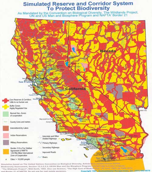
Wildlands Project
Many of the areas shown on The Wildland Project maps in RED, as off limits to human use, already have significantly reduced public access & no management or resource harvesting through: Wilderness, Critical Habitat & Roadless Areas. YELLOW Areas are areas of Highly regulated Use where hiking may be allowed, but no homes. Only GREEN areas will allow housing.
Are any of the areas that you currently enjoy to recreate shown as RED, or off limits to human activity, on the Wildland map?
Is your home in a YELLOW Area, where housing will ultimately be prohibited through increased taxation & impossible regulations?
-
In 1992 The Wildlands project was Mandated by the Convention on Biological Diversity, The Wildlands Project, UN & US Man & Biosphere Program & NAFTA Border Agenda 21.
-
The Agenda 21 UN document pledging to evaluate progress made in implementing the plan, was signed by President George Bush Senior in 1992.
-
The President's Council on Sustainable Development (Agenda 21) was created by President Clinton in 1993, creating a method to implement The Wildlands project through Specific Plans in communities across the nation.
While this may sound too incredible to be true, aren't many of the steps already in place to make The Wildlands Project & Agenda 21 a reality?
If you want to do something about stopping the Wildlands Project then:
-
Read the Sustainable Development Guide for Public Officials to find out about Agenda 21, the driving force to remove people from the land & create greater government control
-
Hand out the Sustainable Development Guide for Public Officials to your elected officials & friends
-
Talk to your friends & associates about it.
-
Join others in your area & inform your local elected leaders, many of whom know nothing about Agenda 21 or The Wildlands Project.
Click Here for Wildlands Project Map of entire US